Wintering in Chicago

Trip reports/posts are recorded in chronological order on last day of each travel segment.
Viewing on a larger screen is recommended.
our photo travel log
Wintering in Chicago
Trip reports/posts are recorded in chronological order on last day of each travel segment.
Viewing on a larger screen is recommended.
We crossed 5000 masl for the first time during our trip to ☞ Bolivia in November 2004. In fact, we spent some time at elevations 3600-3800m for the first time visiting Lake Titicaca and Salar de Uyuni. We traveled by car from Villa Tunari at 260m to Cochabamba, then by air to La Paz, by taxi to bus terminal and by bus to Copacabana at 3840m where we stayed overnight. But not until we walked up to viewpoint on Cerro Calvario 3960m for sunset. All in a day. We both had mild headache, but who knows why? Elevation gain, intense travel, bus filled with diesel fumes or walking back to town without flashlights.
A few days later, we took mini bus from La Paz to Mount Chacaltaya Laboratory at 5230m and walked to Chaclataya Summit at 5421m.
We continued high altitude hiking in ☞ Ecuador in December 2008 on Quilotoa Rim 3700-3900m, but made it only to 5000m marker at the glacier’s edge just past Refugio José Félix Ribas (4850m) on Cotopaxi (5897m). We crossed 5000m again on ☞ Ausangate loop 2016 – Jampa (Yanajaja) at ca 5550m remains our highest point. And again on ☞ Gokyo trek 2018 – Gokyo Ri 5350 m and Renjo La 5375m. We were 15 m shy of 5000 on ☞ Mt Kenya 2017 – Point Lenana 4985m. More recently, we spent many days hiking between 3000 and 4000m on ☞ John Muir Trail 2021 and ☞ Colorado Trail 2025, but crossed over 4000m only on Forester Pass (4009m) and Mt Whitney (4421m).
We ran out of time to tackle 6k.
| masl | ||
| 3806 | Rolling Mountain Pass San Juan Mountains | USA |
| 3930 | Monte Juyende Quilotoa Rim | Ecuador |
| 3960 | Cerro Calvario Lake Titicaca | Bolivia |
| 4009 | Forester Pass Sierra Nevada | USA |
| 4421 | Mount Whitney Sierra Nevada | USA |
| 4985 | Point Lenana Mt Kenya | Kenya |
| 4990 | Gokyo Lake V Khumbu | Nepal |
| 5000 | Cotopaxi glacier | Ecuador |
| 5100 | Jampa Pass Ausangate massif | Peru |
| 5100 | Palomani Pass Ausangate massif | Peru |
| 5350 | Gokyo Ri Khumbu | Nepal |
| 5375 | Renjo La Khumbu | Nepal |
| 5421 | Mount Chacaltaya Cordillera Real | Bolivia |
| 5550 | Jampa (Yanajaja) Ausangate massif | Peru |


Over the years Piotr generated GPX files (tracks) for many of our hikes for navigation, but mostly to just quickly find and record our position on map, and afterwards to illustrate our reports. Now all the tracks are on one interactive map with searchable list of markers linked to corresponding posts and downloadable GPX files (markers with trailhead icon). Altogether quite a bit of memorable walking (2500 km). The map is designed for use on larger screens.


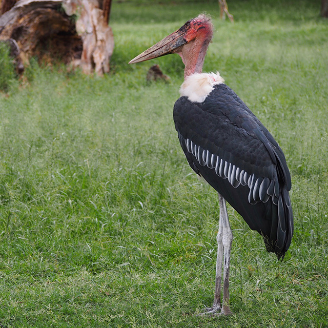
We always liked observing wildlife surrounding us on trails. For birds, we did not make any special effort to identify species. Until we travelled to Galápagos Islands and then to Ecuador where we visited a couple of destinations to watch hummingbirds. In Kenya, focus on big game did not distract us from birdwatching. We saw many species thanks to great skills and knowledge of our driver/guide. We were then ready for birding in Australia and Florida. At first, we tried to find and document birds we could photograph. Without advanced equipment mostly larger and slower species. Identification from photos is easy. With ☞Merlin we added additional tool: recorded song spectrum analysis. Now we listen and then look around to find the birds once we know what to look for. We hear and often see smaller, swift birds as well. Added new section to our website: Birding.