Grand Teton-Yellowstone-Bighorn Mountains-Black Hills-Badlands

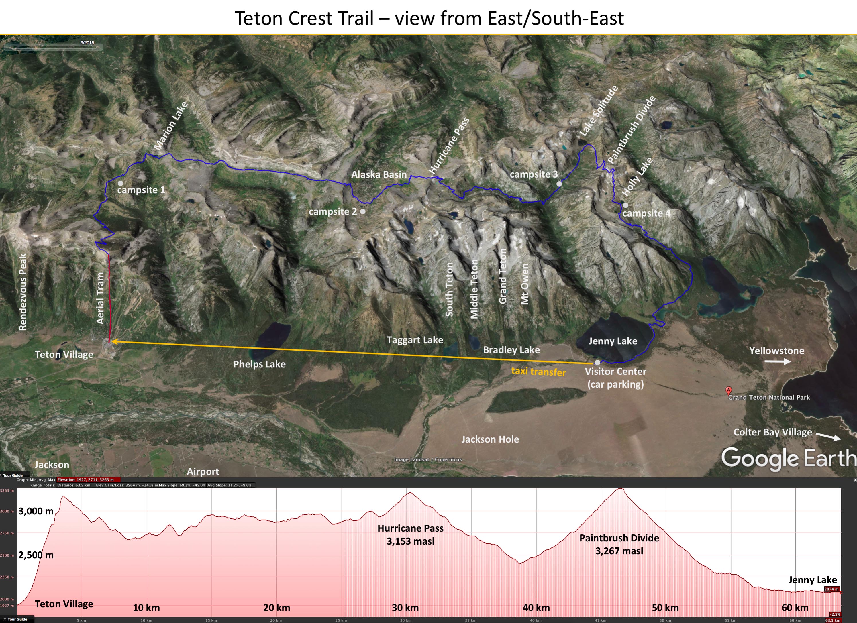
Itinerary: Chicago ➜ North Platte ➜ Rock Springs ➜ Jackson ➜ Craig Thomas Discovery & Visitor Center/Rockefeller Preserve/Phelps Lake trail ➜ Jackson ➜ ☞ Grand Teton Crest Trail ➜ Colter Bay Village/Taggart/Bradley Lake trail ➜ ☞ Yellowstone ➜ Cody/Granite Pass/Buffalo ➜ Devils Tower ➜ Black Hills/Lead/Keystone/Custer State Park-Wildlife Loop Rd ➜ Hot Springs/Jewel Cave/Sylvan Lake/Cathedral Spears trail/Needles Eye/Custer State Park ➜ Badlands Sage Creek Rim Rd and Rt 240-Cliff Shelf/Notch and Castle trails ➜ Sioux Falls ➜ Chicago

In addition to Teton Crest trail and many walks in Yellowstone we also hiked to Phelps Lake, Bradley and Taggart Lakes, and Cathedral Spears.

Phelps Lake (7km)Phelps Lake (West side), Lake Creek Trail – Woodland Trail loop from Laurance S. Rockefeller Preserve building, 7 km
Click on wikiloc logo to see more details

Bradley and Taggart Lakes (10.5 km)Bradley Lake and Taggart Lake loop from Taggart Lake Trailhead on Teton Park Road, 10.5 km
Click on wikiloc logo to see more details

Cathedral Spears (7 km)Walk along Sylvan Lake (1 km), transfer by car to Little Devil’s Tower Trailhead (Rt 87), Trail 4 to Cathedral Spires and Little Devil’s Tower Trails, Trail 4 return, 7 km
Click on wikiloc logo to see more details


Yellowstone

Yellowstone was part of ☞ Grand Teton-Yellowstone-Bighorn Mountains-Black Hills-Badlands trip in 2013. We moved around a lot driving from destination to destination and then walking on local trails, such as Lone Star Geyser trail. We liked our only longer/all-day hike around Grand Canyon of the Yellowstone a lot.

Lone Star Geyser trail map

Click on wikiloc logo to see more details

Grand Canyon of the Yellowstone trail map

Click on wikiloc logo to see more details

Video clips
 

Day 1: South Entrance-West Thumb Geyser Basin-Gull Point-Fishing Bridge-Mud Volcano-Canyon Campground

Day 2: Grand Canyon of Yellowstone-Lower Falls- South Rim trail-Artisan Point-Clear Lake trail-Upper Falls-North Rim trail-Grand View-Inspiration Point

Day 3: Petrified Tree-Specimen Ridge trail-Lamar Valley

Day 4: Hayden Valley-Norris Geyser Basin (Porcelain Basin-Back Basin)- Nymph Lake-Twin Lake-Roaming Mountain-Obsidian Cliff

Day 5: Mammoth Hot Springs-Boiling River Hot Springs-Gibson Falls-West Yellowstone

Day 6: Fountain Pen Pots-Pocket Basin-Midway Geyser Basin-Grant Prismatic Spring

Day 7: Upper Geyser Basin North-Morning Glory-Biscuit Basin-Old Faithful Lodge

Day 8: Lone Star-Upper Geyser Basin

Day 9: Old Faithful-Kepler Cascade-Fishing Bridge-Steamboat Point-East Entrance

Grand Teton Crest Trail

Jenny Lake ➜Teton Village ➜ Teton Crest trail ➜Jenny Lake, part of ☞ Grand Teton-Yellowston-Bighorn Mountains-Black Hills-Badlands trip in 2013.

From Jenny Lake parking lot to Teton Village by hired private car. 5-day Teton Crest trail from Teton Village to Rendezvous Mountain by Aerial tram, then 60 km to Jenny Lake, total elevation gain 2100 m (loss 3300 m), between 1900 and 3328 masl.

Teton Crest trail map

Click on wikiloc logo for more info

Teton Crest trail profile


Manistee River Trail

Flashback of ☞ Michigan Manistee River and North Country Trail loop hike between Red Bridge and Suspension Bridge in July 2013. During this trip we also kayaked with friends on ☞ Pine River upstream of Peterson Bridge. We camped at☞ Pine Lake campground.

Manistee River loop from Red Bridge (31.5 km)Manistee River Trail-Northern Country Scenic trail-Manistee River Trail spur-Suspension Bridge-Manistee River Trail, loop from Red Bridge on North Coates Highway. 31.5 km (one day).
Click on wikiloc logo for more info
 
error: